Warwickshire’s Jurassic Park: How the Rocks make the landscape
WGCG has installed one (of three planned) interpretation boards for the Burton Dassett Hills Country Park in co-operation of the WCC Ranger for the hills.
Please click here (or image, right) to see and read a full-screen PDF of the panel.
The Burton Dassett Hills are Local Geological Site LoG33 and information can be found in the LGS section of our website.
The information shown below is also available to download and print:
“The Burton Dassett Hills Country Park – Introduction to the Geology by WGCG”
A longer read with more detail are in this PDF: Burton Dassett Hills Country Park Geology
Footnote shows how to get to The Burton Dassett Hills Country Park
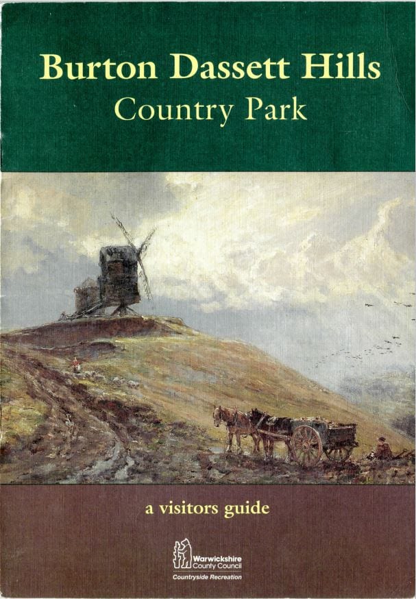
This Warwickshire County Council and Rover Group sponsored visitors guide to the Burton Dassett Hills contains some wonderful old photos of ironstone quarrying, made possible by the hills’ geology (see below). It also has easy-to-read histories of these hills’ most interesting past.
Click here or pic to see PDF.
The Burton Dassett Hills – Warwickshire’s Jurassic Park
Introduction
The Burton Dassett Hills in South Warwickshire cover a 100-acre site, which was designated as a country park by Warwickshire County Council in 1972. As well as the spectacular views and opportunities for outdoor activities, there is historical interest including a 12th Century Church, the site of a Saxon graveyard, ancient springs, ridges and furrows and the Beacon, a circular tower built on one of the hill tops. This tower, probably built in the 15th Century may have been:
- a Beacon tower, used to send messages around the country by lighting fires,
- a windmill, of which the upper storey has been removed (the hill is called Beacon Hill or Windmill Hill),
- a Warrener’s lodge, the home of a man who looked after and supplied the local area with rabbits.
Most unusual for a hilly site, the highest land, including some hill tops have been removed as the ironstone rock has been quarried at various times.

A History of Ironstone Quarrying
The rusty brown or orange rock that was dug out has several names:
- Marlstone Rock Bed or Marlstone Formation; this is its scientific name,
- Hornton Stone; this is one name for the building stone from which many houses in North Oxfordshire and Southern Warwickshire are constructed,
- Banbury Ironstone, this is because the iron content was just enough (around 25%) for it to be used as a raw material for the production of iron and steel and was usually sent to South Wales.
The removal of blocks of the rock for a building stone has probably taken place for many centuries but commercial quarrying probably took place intermittently between 1865 and 1876, between 1898 and 1912 and between 1918 and 1925. Although the iron ore was easy to work and had a high lime content, the small area of workable stone and the difficulties of transporting it to railway stations made the economics of quarrying dependent on a high price for the ore. Up to 53 people were, however, employed at maximum. For most of the life of the quarries, horses pulled railway wagons along tracks, constructed from the rock faces to a collecting point at Gallow’s Hill (west of the toilets). Abandoned wagons were still around in the late 1920s. A steam locomotive was tried for short time. Steam-driven aerial ropeways then carried the ore in buckets downhill before its arrival at a main road or the rail head at Burton Dassett Siding alongside the Warwick to Banbury Road. The production of iron ore from the Burton Dassett Hills was tiny compared with quarrying at Edge Hill, Hook Norton and Wroxton. The decline of steel making in the U.K. in the 1960s finally led to the closure of all but a few local quarries now satisfying only an intermittent demand for building stone and road stone.

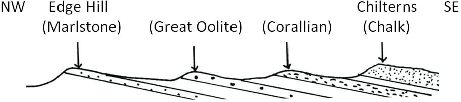
The geological map of England and Wales (opposite) shows that the rocks of Southern Warwickshire and North Oxfordshire are in a zone (shaded blue) which stretches from Dorset through the Cotswolds to North Yorkshire. These rocks were formed during the Jurassic Period of time, roughly between 135 and 195 Ma (million years) ago. The rock layers are tilted very gently towards the south east and disappear below younger Cretaceous rocks (green). Rocks that are more resistant to the forces of nature, such as the four labelled in the sketch section below, form higher ground in the area. The lower ground is formed of the less resistant rocks, often clays, which weathering, rain and rivers remove more easily. When the rocks have been tilted by earth movements, it creates steep slopes when the rocks are ‘end on’. Edge Hill and Warmington Hill are two such examples with the Marlstone.

The Jurassic Period is one of 3 Periods in the Mesozoic (Middle Life) Era or the ‘Age of Reptiles’, when dinosaurs and others dominated life on land. Two major extinction events mark the boundaries of the Mesozoic. At the Palaeozoic/Mesozoic boundary, around 225 Ma ago, an estimated 90% of marine species became extinct. At the end of the Mesozoic Era around 65 Ma ago, major groups including the dinosaurs, ammonites and belemnites became extinct. The subsequent Cainozoic (recent life) Era saw the dominance of mammals, including primates. Modern man (Homo Sapiens) only evolved less than 200,000 years ago, late in the Pleistocene, an epoch over 2 Ma long of at least 20 ‘ice ages’ with warmer ‘interglacials’ in between. The Holocene or Recent Epoch, that we are in at the moment, is likely to be another interglacial before another ‘ice age’. It began around 10,000 years ago as the last ice age finally ended with the melting ice causing sea levels to rise worldwide and Great Britain to become a series of islands.
The Jurassic rocks of Burton Dassett belong to the Early Jurassic (sometimes called the Lias) and are roughly 175-195 Ma old. This is very old in human terms but young compared with most other British rocks and very young compared with the age of the Earth at around 4,560 Ma, our galaxy at around 10.000 Ma and the Universe at around 13,700 Ma.
Geological time is difficult to envisage. A million, for example, is a huge figure. Counting to a million at one second for each number would take at least 11 days (without sleep). Human beings are not expected to live a million hours, equivalent to over 114 years. Absolute dating of rocks, in millions of years, has a small margin of error but can only be carried out on those rocks which contain radioactive elements whose decay provide reliable ‘atomic clocks’.
Far easier to understand is the idea of relative geological dating. Sequences of events can be worked out with simple logic. In the geological column (above), Cretaceous rocks lie above Jurassic rocks, so are younger. Since their formation, for most part below sea level, both the Jurassic and Cretaceous rocks have been affected by earth movements which have uplifted them above sea level and tilted them towards the south east. This has to have been followed by a long period of erosion to expose the various rocks to be seen on the surface today. Fossils preserved within rocks provide the most valuable method in finding the relative age of any rock layer. The fossil record is a very detailed and valuable account of the continuously evolving history of life on Earth.
Jurassic Times in the United Kingdom

This map shows the likely geography of the Lower Jurassic. The climate was warm and humid. The seas were sometimes fairly deep, sometimes shallow and sometimes retreated to expose land. There were ‘swell’ areas where the sediments are very thin, or the area was above sea level. The London area was usually above sea level and home to plenty of dinosaurs. There were ‘basins’ which filled up with large thicknesses of sediment. Most of the mudstones, siltstones, sandstones, limestones and ironstones of the Jurassic were deposited in marine environments. These rocks contain abundant fossils that allow, through the rapid evolution of ammonites, a very detailed relative dating of the rocks into many fossil zones, some less than a million years in length.


In Jurassic times, the present-day continental blocks were joined together into a ‘super-continent’ (Pangaea). There was an ocean (Tethys) between the southern continents and Asia. This would close during the Cainozoic Era with continental collisions leading to the formation of mountain ranges such as the Alps and the Himalayas. The Americas began breaking away from Africa during the Jurassic but with Scotland attached to Greenland at this time, the North Atlantic Ocean did not yet exist.
There is clear evidence that the Earth was much warmer during the Jurassic than it is today, and sea levels were high. Shallow seas existed over many parts of Europe including our area. The Midlands was also warmer than today because the British Isles lay somewhere between 30 and 35 degrees of latitude north of the Equator, similar to North Africa now. The British Isles has been moving northwards since being in the southern tropics over 400 million years ago. The average rate of movement works out only around 2 centimetres a year.
Jurassic Rock Types of the Burton Dassett Hills

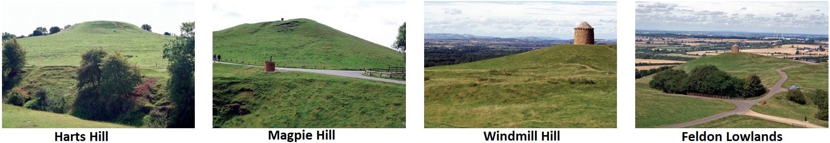
Northampton Sands
These are found at the top of Harts Hill. A lack of significant fossils has meant that the rock cannot be dated very accurately but, lying above the Whitby Mudstone, they appear to belong to the Middle, rather than the Lower Jurassic.
Whitby Mudstone
This is found under the ‘ridge and furrow’ on the steeper slope below the top of Harts Hill. These muddy rocks have their equivalents in such places as Brailles, Hanwell and Crouch Hill, Banbury.
Marlstone Rock Bed
This was the rock that was extensively quarried where it was exposed. The Marlstone is extremely variable in its chemistry and physical components, but it contains a variety of fossils, especially primitive seashells.
Dyrham Formation (Middle Lias Silts)
These siltstone rocks are exposed below the Marlstone Rock Bed and consist largely of fine grains which are uniform in size. Fossils are common, mainly seashells. These rocks have their equivalents in the Banbury area where they are frequently found on the slopes around the town centre, e.g., on the Warwick Road, Broughton Road, Oxford Road and the slope up to Middleton Cheney.
Charmouth Mudstone (Lower Lias Clay)
This surrounds the Burton Dassett Hills and occupies much of the lowlands in this part of Warwickshire and Oxfordshire; and extends along the valley of the River Cherwell to Banbury Town Centre.
The Present is the Key to the Past
This phrase sums up the principles that are used to suggest the conditions under which various rock types have been formed. By studying the fossil content, grain sizes, grain shapes and the mineral components of a rock, it is possible to work out whether the sediment was originally formed in the sea, a river, lake or desert. There may be clues to depth of water and rate of sedimentation as well as determining whether conditions were calm (low energy) or involved strong waves and currents (high energy). Sometimes, the geological detective work is relatively straight forward. For example, the creamy-white limestone that forms much of the Cotswold Hills consists of sand-sized near spherical grains of limestone called ooliths (named because they resemble fish roe). These sediments require tropical or subtropical clear shallow seas as can be easily demonstrated in the Bahamas, off the coast of Florida, where identical grains can be seen forming today. Sometimes there is no situation on the Earth today to compare a sedimentary rock to, as is the case of the formation of the Marlstone Rock, which is not fully understood, especially as evidence can be contradictory. One complication in the geological detective work is the changes that take place as loose sediment is turned into sedimentary rock by the pressure of layers above and the movement of fluids through the sediment.
What Happened After the Jurassic Period?
The sedimentary layers continued to pile up during the rest of the Mesozoic Era with chalk seas once covering almost the whole of the British Isles. Sea levels then fell worldwide. With a shrinking Tethys Ocean, Africa colliding with Europe and mountain ranges forming north of the Mediterranean Sea, rock layers were gently folded and uplifted over a wide area, including southern England. Movements are also connected with the North Atlantic opening up about 70 Ma ago. Since then, over 400 metres of younger rock has been eroded from over Warwickshire and Oxfordshire to expose the rocks we see today.
The Formation of Our Current Landscape
Studying landscapes involves a completely different time scale to that when dealing with the formation of rocks millions of years ago in the Jurassic Period. Landscape features generally evolve over only tens of thousands of years at the most. Some parts of England have been covered in ice sheets as often as they have been free of ice, so the working of moving ice and the effects of permanently frozen ground has to be considered as well as the work of weathering, slope movements and the rivers that are acting today.
When viewed from Beacon Hill, the county of Warwickshire appears much lower in height than both the Burton Dassett Hills and the hills in the background to the south west such as Edge Hill across the Cherwell Valley. This shows a fundamental control on the landscape of the British Isles: the more the local rocks are able to resist erosion, the higher above sea level the area is likely to be. Mountain areas such as the Scottish Highlands, The Lake District, Snowdonia and Dartmoor are made of very resistant rocks while most of the Midlands and East Anglia is composed to less resistant rocks that have been worn down to create lowland areas. In the local area, once the cap of more resistant Marlstone Rock is eroded from the hill tops in this area, the landscape is lowered as the rocks below it are quickly removed.

The sketch above shows that the rock layers of Lower Jurassic age were once continuous between Burton Dassett and Edge Hill. A wide valley has been cut down at least 50 metres into these rocks, but there is no big river in between to have formed it. One possible explanation lies with the ice ages of the Pleistocene Epoch when ice sheets hundreds of metres thick covered much of Britain. We know that ice from the Irish Sea crossed the Midlands and left debris over many parts of Warwickshire when it melted. Water pouring off a melting ice sheet could have been dammed by the local hills, possibly even creating a huge lake covering Warwickshire and Leicestershire. If this lake overflowed between Edge Hill and the Burton Dassett hills, there would have been plenty of extra water to cut valleys both to the west and the east of the Burton Dassett Hills. — Ends —
Directions for Burton Dassett Hills Country Park
(Sat nav CV47 2AB)
From Junction 12 of M40 Turn towards Gaydon (NB considerable roadworks currently around this Junction)
On edge of Gaydon, turn towards Banbury on B4100.
Continue for about 2 miles (large army camp on right).
Turn left towards Northend and Burton Dassett.
Continue straight up hill over Cattle Grid and climb hill to the junction at the top. The cash machine for parking is at this point.
When you have paid turn to the left and there is a car park below the “Beacon” which looks like the bottom of a windmill.
Last Updated on 08 Sep 2021